
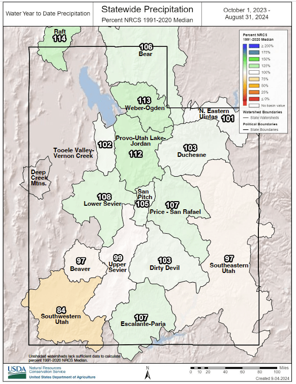
In Utah’s valleys, statewide water year accumulation since October 2023 measures at 105% of median. That’s thanks to a rainier-than-normal August, according to the latest Utah Water Conditions Update.
Utah received 1.5 inches of precipitation, 160% of normal, at Soil Climate Analysis Network (SCAN) sites, which measures the low elevation precipitation that is critical for agricultural production and operations, the report said.
Statewide soil moisture at Utah’s SCAN sites ended the month at 39% of saturation. While this is the same percentage as last month, the report said, the percent of normal is higher since it is not unusual for late summer soils to be quite dry around the state. The report notes that soil moisture data from several SCAN sites are missing due to sensor issues which, when integrated across multiple sites, lowers the region-wide value displayed herein, the report said.
As for higher-elevation mountain conditions, while Utah’s mountains typically get some decent precipitation during the month of August due to the seasonal monsoon, this year’s August was better than average, the report said. Utah received 2.7 inches of new precipitation during the month, which is 178% of normal. This brings the statewide water year to date precipitation to 105% of normal, up 2% from last month, the report said.
Utah’s mountain soil held the monsoonal moisture pretty well, the report said, though it notes that soils have been quickly drying since most of that precipitation fell in the middle to late portion of August.
Statewide depth-averaged soil moisture is currently at 39% of saturation, 7% lower than at this time last year, according to the update.
Regarding water availability, the report said that statewide storage is now at 77% of capacity, which is 6% lower than last month.
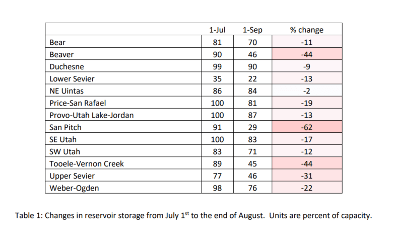
“Similar to what was presented in last month’s Climate and Water Report, Table 1 (in the attached report and shown above) compares reservoir levels for each of Utah’s major basins and shows the degree of change from a couple months ago,” the report read. “While some areas of the state have been able to retain a large percentage of their storage capacity (e.g. the Northeastern Uintas and Southwestern Utah, as well as the Duchesne, Bear, and Provo watersheds), others such as the San Pitch, Upper Sevier, and Beaver watershed, as well as the Tooele-Vernon Creek area have depleted available water resources at a faster rate.”
Though state reservoirs are in a good position, the update urges water managers to not rule out the possibility of returning to a drought mentality in the coming years.
“Water Availability Indices (WAIs) for Utah basins combine current reservoir conditions with observed monthly streamflow for each region. WAIs are below normal (50th percentile) for the Blacks Fork, Smiths Fork, and Lower Sevier areas. Conversely, water availability conditions are well above normal for this time of year in the Ogden, Provo, Price, and Ferron Creek watersheds,” the report read.